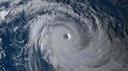
TOKYO, Sept. 12 (Xinhua) -- Typhoon Muifa has brought heavy downpours and gale-force winds to islands in the southwest of Japan's Okinawa, Japan's weather agency said Monday.
According to the Japan Meteorological Agency (JMA), as of 11 a.m. local time, Typhoon Muifa was over waters 30 kilometers south of Ishigaki Island with an atmospheric pressure of 955 hectopascals at its center and maximum wind speeds of up to 216 kilometers per hour.
The JMA, along with warning residents in the typhoon's path to remain vigilant for landslides and rivers breaching their banks, also said the typhoon is packing winds strong enough to damage if not topple homes.
The slow-moving typhoon, the 12th of the season, is expected to continue to bring severe weather conditions to the Sakishima Islands through Wednesday as it moves northward, the JMA said.
On Hateruma Island, in the 24 hours through 9 a.m. local time on Monday, a record 352.5 millimeters of rainfall was recorded.
Up to 70 millimeters of rainfall per hour is expected in the Sakishima Islands on Monday, while 42 millimeters of rainfall per hour is expected to hit Ishigaki, the agency said.
The JMA said the atmospheric pressure is extremely unstable as a result of the typhoon and while wind speeds may decrease to 72 to 108 kilometers per hour on Wednesday, Okinawa could see as much as 300 millimeters of rainfall in the 24-hour period through noon on Tuesday.
In the 24-hour period though noon on Wednesday, meanwhile, 50 to 100 millimeters of rain is expected, the weather agency said.
The powerful typhoon has caused disruption to transportation services in the region, with Japan's two top carriers Japan Airlines and All Nippon Airways canceling flights to and from the popular tourist destinations of Miyako and Ishigaki islands.


